Most homeowners start looking up a boundary survey cost after something goes wrong. A neighbor builds a fence. A permit gets flagged. A home sale stalls because no one can agree on where the property line is.
What a Boundary Survey Does
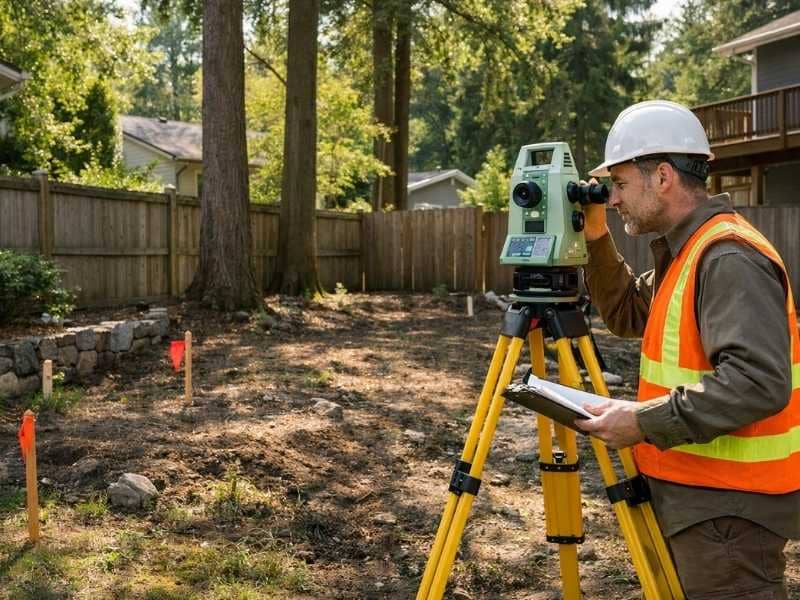
A boundary survey has one job. It finds the legal edges of your property. A surveyor locates the corner markers, takes measurements, and creates a certified document that shows exactly where your land starts and ends.
This is not the same as a topographic survey, which maps the shape and elevation of the land. And it is not the same as a general property survey, which may show buildings and other features. A boundary survey answers one specific question: where is the line?
In San Francisco, that question matters a lot. The city is dense. Lots are small. Buildings from different time periods sit right next to each other. Being off by even one foot can cause real problems when every inch of space has value.
Boundary Survey Cost in San Francisco Right Now
In San Francisco County, a standard residential boundary survey typically costs between $800 and $1,500. That range is not just about lot size. It reflects how complex the local market is.
California has some of the highest survey costs in the country. Labor is expensive. Environmental rules are strict. Land use laws are detailed. San Francisco sits at the top of even that high statewide range.
To put it in context, the same survey on a simple lot in California’s Central Valley might cost $500 to $900. San Francisco costs more because the research takes longer and the fieldwork is harder, not because the lots are bigger.
Why Boundary Surveys Cost More in San Francisco
A few things specific to San Francisco push the price above what you would pay in most other cities.
Earthquake and liquefaction zones. San Francisco is one of the most seismically active places in the country. State law requires that certain high-risk zones be mapped and investigated before construction can move forward. If your property sits in one of these zones, the surveyor may need to work with other licensed professionals to meet permit requirements. That takes more time and costs more money.
Natural hazard disclosures. California law requires sellers to tell buyers whether a home sits in an Earthquake Fault Zone or a Seismic Hazard Zone. When a boundary survey is part of a property sale, the timing of the survey sometimes has to line up with these disclosure deadlines. That can affect the scope and schedule of the work.
The Alquist-Priolo Fault Zone. California has a law called the Alquist-Priolo Earthquake Fault Zone Act. It requires sellers to tell buyers if any part of the property falls within a designated fault zone. A boundary survey is often the first step in figuring out exactly where a parcel sits relative to that zone.
Getting to the site in a dense city. Surveyors working in neighborhoods like the Mission, the Richmond, or SoMa deal with heavy traffic, limited parking, and tight access around occupied buildings. These are real costs that get built into the quote.
What Is Included in the Price
A boundary survey quote covers more than someone walking around your yard with equipment. Here is what the price normally includes:
- Reviewing your deed and title records to confirm the legal description of your land
- Checking recorded plats, past surveys, and county records
- Measuring the lot and locating existing boundary markers
- Setting new corner markers where old ones are missing or damaged
- Creating a certified survey drawing with the surveyor’s official stamp
- Writing a legal description of the boundary if it is needed for permits or title work
Some things are often not included in the base quote. These can include government filing fees if a Record of Survey must be filed with the county, extra copies of the certified drawing requested by lenders or lawyers, and any follow-up work needed if a boundary dispute comes out of the findings.
Always ask for a written breakdown before you agree to anything. A clear, itemized quote means the surveyor has thought through what your specific job actually involves.
When You Actually Need a Boundary Survey
A boundary survey makes sense in these situations:
- You plan to build a fence, add a room, or put up a new structure near the edge of your property
- A neighbor is disputing where the line falls and you need a legal document to settle it
- You are applying for a city building permit that requires confirmed boundary information
- You are buying a property and want to confirm the lot matches the legal description
- You are applying for a lot line adjustment or subdivision
A boundary survey is not always needed. If you are refinancing and not doing any construction, your lender may accept an older survey or a simpler document. Knowing which type you actually need before you order one can save you real money.
How to Compare Quotes Without Getting Caught Off Guard
Getting more than one quote is a smart move. But comparing quotes takes some care. Two quotes for the same property can look very different depending on what each one covers.
When you look at quotes side by side, check whether each one covers everything your project needs. A low quote that leaves out monument setting, county filing fees, or any follow-up work will not stay low once the job starts.
Also check that the surveyor is licensed in California. The California Board for Professional Engineers, Land Surveyors, and Geologists has a free public tool to verify licenses. Only a licensed surveyor’s stamp makes the final document valid for permits, sales, and legal purposes. Without that stamp, the document has no legal standing.
Frequently Asked Questions
Does a boundary survey affect my property taxes ?
A boundary survey on its own does not cause a tax reassessment. But if the survey shows your lot is bigger than the official record says, or if the work leads to a lot line adjustment that changes the parcel size, the assessor’s office may update the file. It is worth knowing this before the work starts, especially if the result could change your tax bill.
Can a boundary survey support a lot line adjustment application in San Francisco?
Yes. San Francisco’s Planning Department requires a licensed survey as part of any lot line adjustment application. The boundary survey documents the existing lines before any changes are proposed. The survey must show current conditions and carry the stamp of a licensed California land surveyor.
What is a Record of Survey and when does California require one?
A Record of Survey is a legal document filed with the county recorder’s office. It formally records the results of a boundary survey. In California, surveyors must file one when they set new markers, when their findings differ from a previously recorded survey, or when the parcel has never had a recorded survey before. Filing fees vary by county and are not part of the surveyor’s professional fee.
How does the Alquist-Priolo Earthquake Fault Zone affect a boundary survey?
The fault zone does not change how the survey is done. But if your property is in or near one of these zones, you may face extra permitting steps before any construction can begin. A boundary survey is often the first step in figuring out where your parcel sits in relation to the zone line, and that information matters for your overall project planning.
What happens if two licensed surveyors come up with different boundary lines?
It does happen, especially on older lots with little prior documentation. When two certified surveys conflict, the disagreement is usually resolved by reviewing the chain of title, the order of recorded documents, and the physical evidence on the ground. A licensed surveyor can document the conflict and give a professional opinion. If the two sides still cannot agree, an attorney may need to get involved.

 Land Surveyors are professionals who make precise measurements to determine the size and boundaries of a piece of real estate. While this is a simplistic definition, boundary surveying is one of the most common types of surveying related to home and land owners. If you fall into the following categories, please click on the appropriate link for more information on that subject: